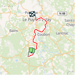
![](/images/other/stat-length.png)
![Excursión Bicicleta Le Brignon - Voie verte - descente sur Le Puy en Velay - Photo](https://media.geolcdn.com/t/1900/400/ext.pjpeg?maxdim=2&url=https%3A%2F%2Fstatic1.geolcdn.com%2Fsiteimages%2Fupload%2Ffiles%2F1524743154velo.jpg)
Voie verte - descente sur Le Puy en Velay
cathyetyves
Usuario
![Longitud](/images/other/stat-length.png)
![Altitud máxima](https://static1.geolcdn.com/siteimages/upload/files/1508320355ic_sort_altitude_max_24dp.png)
![Desnivel positivo](https://static1.geolcdn.com/siteimages/upload/files/1508320355ic_sort_den_pos_24dp.png)
![Km-Effort](/images/other/stat-length.png)
![Altitud mínima](https://static1.geolcdn.com/siteimages/upload/files/1508320355ic_sort_altitude_min_24dp.png)
![Desnivel negativo](https://static1.geolcdn.com/siteimages/upload/files/1508320355ic_sort_den_neg_24dp.png)
![Boucle](https://static1.geolcdn.com/siteimages/upload/files/16400158638029165_repeat_loop_refresh_sync_direction_icon.png)
![Bicicleta](https://static1.geolcdn.com/sitytour/trail-icons/200.png)
1h49
Dificultad : Muy fácil
![Escanee este código QR para abrir la excursión en la aplicación SityTrail](https://capi.geolives.com/qq0zvz2zws4bq2lad0pu/sitytour/trails/431202/qr.png?size=200)
Aplicación GPS de excursión GRATIS
A propósito
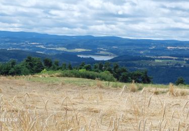
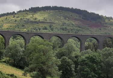
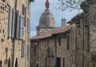
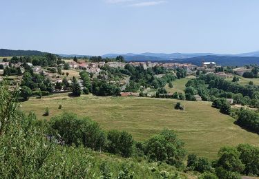
Ruta Bicicleta de 26 km a descubrir en Auvergne-Rhône-Alpes, Alto Loira, Le Brignon. Esta ruta ha sido propuesta por cathyetyves.
Descripción
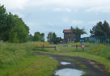
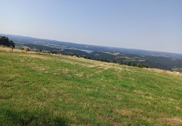
Le parcours emprunte une ancienne voie de chemin de fer, la voie est recouverte de petits graviers très roulants pour les vélos, des paysages magnifiques, plusieurs tunnels éclairés, pour certains de près de 1200 m, une descente en pente douce sur le Puy en Velay.
Localización
Comentarios
Excursiones cerca
![Excursión Senderismo Solignac-sur-Loire - cascade de la beaume haute loire - Photo](https://media.geolcdn.com/t/375/260/ec965890-39b5-4237-9849-2251ccda9c3d.jpg&format=jpg&maxdim=2)
![Senderismo Senderismo](https://static1.geolcdn.com/sitytour/trail-icons/101.png)
Senderismo
![](/images/other/stat-length.png)
![](https://static1.geolcdn.com/siteimages/upload/files/16400158638029165_repeat_loop_refresh_sync_direction_icon.png)
![Excursión Senderismo Le Bouchet-Saint-Nicolas - STEVENSON Le Boucher St Nicolas à Pradelles - Photo](https://media.geolcdn.com/t/375/260/e589f375-fa46-4575-a377-24d61a2088b8.jpg&format=jpg&maxdim=2)
![Senderismo Senderismo](https://static1.geolcdn.com/sitytour/trail-icons/101.png)
Senderismo
![](/images/other/stat-length.png)
![](https://static1.geolcdn.com/siteimages/upload/files/16400158638029165_repeat_loop_refresh_sync_direction_icon.png)
![Excursión Senderismo Cayres - Grand tour du Lac du Bouchet - Photo](https://media.geolcdn.com/t/375/260/6c5e80eb-92ec-4387-9dae-8b2160e14ba4.jpg&format=jpg&maxdim=2)
![Senderismo Senderismo](https://static1.geolcdn.com/sitytour/trail-icons/101.png)
Senderismo
![](/images/other/stat-length.png)
![](https://static1.geolcdn.com/siteimages/upload/files/16400158638029165_repeat_loop_refresh_sync_direction_icon.png)
![Excursión Senderismo Le Bouchet-Saint-Nicolas - Etape 2 Bouchet st Nicolas Pradelles - Photo](https://media.geolcdn.com/t/375/260/e26470b1-7d09-4c3c-b167-76eb852efcc5.jpg&format=jpg&maxdim=2)
![Senderismo Senderismo](https://static1.geolcdn.com/sitytour/trail-icons/101.png)
Senderismo
![](/images/other/stat-length.png)
![](https://static1.geolcdn.com/siteimages/upload/files/16400158638029165_repeat_loop_refresh_sync_direction_icon.png)
![Excursión Senderismo Le Bouchet-Saint-Nicolas - Le Bouchet St Nicolas,Pradelle - Photo](https://media.geolcdn.com/t/375/260/831a6e71-aff7-41f0-8059-9cd2ff7041df.jpg&format=jpg&maxdim=2)
![Senderismo Senderismo](https://static1.geolcdn.com/sitytour/trail-icons/101.png)
Senderismo
![](/images/other/stat-length.png)
![](https://static1.geolcdn.com/siteimages/upload/files/16400158638029165_repeat_loop_refresh_sync_direction_icon.png)
![Excursión Senderismo Le Bouchet-Saint-Nicolas - 08-05-2023 E3 Le Bouchet Saint Nicolas - Langogne - Photo](https://media.geolcdn.com/t/375/260/8bb6a970-0785-4062-8d5d-6982f88c1225.jpg&format=jpg&maxdim=2)
![Senderismo Senderismo](https://static1.geolcdn.com/sitytour/trail-icons/101.png)
Senderismo
![](/images/other/stat-length.png)
![](https://static1.geolcdn.com/siteimages/upload/files/16400158638029165_repeat_loop_refresh_sync_direction_icon.png)
![Excursión Senderismo Le Bouchet-Saint-Nicolas - pradelles - Photo](https://media.geolcdn.com/t/375/260/13ff9535-4401-4af3-86ba-708829cda2d7.jpg&format=jpg&maxdim=2)
![Senderismo Senderismo](https://static1.geolcdn.com/sitytour/trail-icons/101.png)
Senderismo
![](/images/other/stat-length.png)
![](https://static1.geolcdn.com/siteimages/upload/files/16400158638029165_repeat_loop_refresh_sync_direction_icon.png)
![Excursión A pie Costaros - Via Regordane - Le Puy - Landos - Photo](https://media.geolcdn.com/t/375/260/59ae3503-7d7b-4a8e-971a-b125868fb91f.jpeg&format=jpg&maxdim=2)
![A pie A pie](https://static1.geolcdn.com/sitytour/trail-icons/100.png)
A pie
![](/images/other/stat-length.png)
![](https://static1.geolcdn.com/siteimages/upload/files/16400158638029165_repeat_loop_refresh_sync_direction_icon.png)
![Excursión Bici de montaña Le Bouchet-Saint-Nicolas - Bouchet - Le Cheylard 2020 - Photo](https://media.geolcdn.com/t/375/260/1abe87dd-eb0f-481e-98ff-920c0c7e3292.jpg&format=jpg&maxdim=2)
![Bici de montaña Bici de montaña](https://static1.geolcdn.com/sitytour/trail-icons/202.png)
Bici de montaña
![](/images/other/stat-length.png)
![](https://static1.geolcdn.com/siteimages/upload/files/16400158638029165_repeat_loop_refresh_sync_direction_icon.png)